
Experimental Plugins
List of approved plugins with at least one experimental version.
1045 records found

Geometric Attributes
A set of tools for calculating attributes along the centerline including width, deviation, transects, shape, sinuosity and adjacency.
2023-05-02T19:25:08.581030+00:00

Geometry Attribute Table
A vector attribute table with geometry descriptions. This plugin was created because colleagues and new users to QGIS inadvertently keep …
2019-06-10T02:04:02.684779+00:00

Geometry copier
Plugin for copying geometry between features
2014-05-07T07:38:09.007892+00:00
Geometry Exporter
The plugin displays the geometry of a selected feature as text. Supported formats: WKT, EWKT, GML2, GML3 and GeoJSON.
2015-11-22T11:02:59.560206+00:00

Geometry Generator
Makes the geometry file for inSALMO
2019-08-19T19:55:05.080659+00:00
Geometry Wrapper
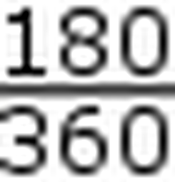
Converts geometry longitude from [-180,180] to [0,360] and vice versa
2019-11-19T03:48:37.767522+00:00

GeoMove Processing provider
Installs GeoMove models and scripts in Processing toolbox
2018-10-11T15:14:32.345880+00:00

GeopaparazziTags converter
convert data from geopaparazzi surveys
2014-02-26T11:04:38.165758+00:00
GeoPF Altimétrie
Warning : France only! <br/> This plugin allows to call IGN Geoplateforme API directly from elevation profile tool.
2024-10-21T16:47:55.342848+00:00

Geo Picker
A geologic picking tool for conceptual model building
2017-06-05T18:38:05.040024+00:00

GeoPortal.rlp Metadata Search
GeoPortal.rlp metadata search module
2024-03-02T12:40:39.411964+00:00

geopunt4Qgis
NL: Plugin om geopunt diensten in QGIS te gebruiken EN: Plug-in to use geopunt services in QGIS
2024-04-21T12:59:53.444581+00:00

GeoQ
Automatización del procesamiento de cálculo de la escorrentía superficial con el método de Número de Curva
2024-11-20T19:16:10.586192+00:00

Georeferencer Extension
Extension to the QGIS 3.x Raster Georeferencer
2025-01-05T17:08:37.153927+00:00

GeorefExport
GeorefExport - Exports the map as a georeferenced raster graphics file. Raster file formats available are PDF, GTiff, JPEG, PNG, …
2014-07-22T20:07:20.005423+00:00

Geoscan Forest
Forest Analysis
2019-07-24T13:57:59.422356+00:00

Geoscience
Tools for Geoscience & Exploration
2024-06-27T13:12:49.540390+00:00

Geosimulation Land Changes
This plugin is a tool used in spatial modeling to predict changes in land cover or land use
2024-12-21T17:05:54.637553+00:00

Geosud Toa Reflectance
TOA reflectance conversion for Satellite data
2015-05-19T10:56:26.121236+00:00

GeoTrace
Collection of tools extracting trace data from commonly used geoscience rasters such as imagery, topography and geophysics.
2023-01-20T02:37:41.199601+00:00
| Name | Author | Latest Version | Created On | Stars (votes) | ||||
|---|---|---|---|---|---|---|---|---|
|
|
Geometric Attributes | 45,419 | Bjorn Nyberg | 2023-05-02T19:25:08.581030+00:00 | 2019-09-05T15:20:16.860886+00:00 |
(35)
|
0.4 | 0.1 |
|
|
Geometry Attribute Table | 6,537 | Philip Whitten | 2019-06-10T02:04:02.684779+00:00 | 2018-11-12T03:26:47.592611+00:00 |
(6)
|
— | 0.1.1 |
|
|
Geometry copier | 9,765 | Nikulin Evgeniy | 2014-05-07T07:38:09.007892+00:00 | 2013-10-31T13:14:25.346754+00:00 |
(10)
|
— | 0.4.1 |
|
|
Geometry Exporter | 7,110 | Juergen Weichand | 2015-11-22T11:02:59.560206+00:00 | 2015-11-21T17:09:59.781942+00:00 |
(12)
|
— | 0.5.1 |
|
|
Geometry Generator | 2,700 | Peter N. Dudley | 2019-08-19T19:55:05.080659+00:00 | 2019-08-06T19:57:32.049458+00:00 |
(0)
|
— | 0.3 |
|
|
Geometry Wrapper | 4,657 | Jonah Sullivan | 2019-11-19T03:48:37.767522+00:00 | 2017-03-20T20:58:02.896946+00:00 |
(4)
|
— | 0.45 |
|
|
GeoMove Processing provider | 3,883 | Luigi Pirelli and David fernandez Arango and Alberto Varela García (CartoLAB) | 2018-10-11T15:14:32.345880+00:00 | 2018-10-11T10:29:31.199231+00:00 |
(15)
|
— | 0.1.1 |
|
|
GeopaparazziTags converter | 21,622 | Pierluigi De Rosa, Andrea Fredduzzi | 2014-02-26T11:04:38.165758+00:00 | 2013-07-22T16:05:33.842645+00:00 |
(16)
|
0.2.2 | 0.2 |
|
|
GeoPF Altimétrie | 458 | Nicolas GODET | 2024-10-21T16:47:55.342848+00:00 | 2024-10-02T13:56:34.037402+00:00 |
(1)
|
— | 0.1.2 |
|
|
Geo Picker | 5,415 | Mason Marchildon | 2017-06-05T18:38:05.040024+00:00 | 2017-05-17T12:32:13.825308+00:00 |
(13)
|
— | 0.1.2 |
|
|
GeoPortal.rlp Metadata Search | 6,367 | Armin Retterath | 2024-03-02T12:40:39.411964+00:00 | 2022-02-17T00:51:39.818464+00:00 |
(7)
|
0.3.2 | 0.3 |
|
|
geopunt4Qgis | 131,456 | Kay Warrie | 2024-04-21T12:59:53.444581+00:00 | 2013-12-15T15:22:57.339324+00:00 |
(61)
|
2.4.0.1 | 2.3.0.3 |
|
|
GeoQ | 1,020 | Fabio Alejandro Montealegre Medina- Fernanda Julia Gaspari | 2024-11-20T19:16:10.586192+00:00 | 2022-03-02T01:23:18.897345+00:00 |
(2)
|
2.8 | 1.4 |
|
|
Georeferencer Extension | 69,270 | Christoph Candido | 2025-01-05T17:08:37.153927+00:00 | 2024-06-01T16:38:29.165621+00:00 |
(33)
|
3.0.8 | 3.0.5 |
|
|
GeorefExport | 25,649 | Ruggero Valentinotti | 2014-07-22T20:07:20.005423+00:00 | 2014-07-18T20:34:03.747349+00:00 |
(80)
|
— | 0.1.3 |
|
|
Geoscan Forest | 4,921 | Geoscan group, Aleksandr Zakora | 2019-07-24T13:57:59.422356+00:00 | 2019-07-24T13:57:59.013469+00:00 |
(52)
|
— | 0.1 |
|
|
Geoscience | 85,759 | Roland Hill | 2024-06-27T13:12:49.540390+00:00 | 2018-09-18T21:47:14.396817+00:00 |
(92)
|
1.15 | 0.62 |
|
|
Geosimulation Land Changes | 95 | Albertus Deliar, Ananda Diva Victorya Gunawan, Elnurmas Zaetun Faesyari, Riki Purnama, Tedy Imanuel Selan | 2024-12-21T17:05:54.637553+00:00 | 2024-12-21T17:05:51.205420+00:00 |
(1)
|
— | 0.1 |
|
|
Geosud Toa Reflectance | 13,632 | Kenji Ose - Irstea | 2015-05-19T10:56:26.121236+00:00 | 2014-03-12T10:48:01.398069+00:00 |
(17)
|
1.0 | 0.2 |
|
|
GeoTrace | 17,392 | Lachlan Grose | 2023-01-20T02:37:41.199601+00:00 | 2017-08-03T00:33:03.217344+00:00 |
(67)
|
— | 1.34 |


