
Experimental Plugins
List of approved plugins with at least one experimental version.
1047 records found

QWater
Hydraulic design and analysis of water supply networks
2024-08-16T17:30:26.232718+00:00

QWaterModel
QWaterModel is a simple tool to calculate evapotranspiration from thermal images.
2023-02-15T14:42:19.328833+00:00

QWC2_Tools
QGIS plug-in designed to publish and manage the publication of projects in a QWC2 instance. The plugin allows you to …
2025-01-15T14:24:29.438175+00:00

QWeb
This plugin enables users to open a window within the QGIS environment where the user can browse through the web.
2020-02-04T15:07:11.292060+00:00

Qweetgis
A QGIS Plugin for Twitter Streaming API
2019-01-22T19:22:40.211677+00:00

RadialBandsTool
Draw desired radial bands for selected point features
2014-06-03T20:05:10.437742+00:00

Radiation ToolBox Plugin
Plugin for loading data from Safecast and other radiation monitoring devices
2024-03-29T04:29:25.548388+00:00

Radiotrack
Visualizes radiotracking data
2021-09-05T20:33:25.119467+00:00

RASOR Plugin
Plugin developed for the FP7 RASOR Project (http://www.rasor-project.eu/)
2016-01-17T12:09:07.040909+00:00

raster2postgis
Import raster to postgis
2024-12-05T22:03:39.003273+00:00

RasterAttributeTable
Display and manage Raster Attribute Tables.
2022-09-28T14:54:11.273813+00:00

Raster Bender
Distort rasters with high local deformation (such as historical maps) to adapt to contemporary data. This feature is also known …
2016-05-29T21:43:52.559277+00:00
Raster Data On Polylines
Extract and manipulate raster data along polylines. Compute integrals, normal and tangent components.
2017-02-17T11:06:22.403411+00:00
raster inversor
The plugin inverts the values of a raster
2019-03-07T22:01:26.049610+00:00

RasterizeString
This plugin extends gdal rasterize command to burn values from non-numeric field.
2019-04-03T12:57:41.232261+00:00

Raster legend sensitive
Change the legend of raster(need have palette) by extent of map and show/hide each item in legend.
2016-02-19T11:07:29.571902+00:00

RasterLoader
Loads rasters from locations given by shapefile field values
2016-03-04T08:27:19.350394+00:00
RasterMCDA
Plugin implementing MCDA calculations, for raster datasets. RasterMCDA was implemented during my Bachelor studies in Geoinformation at the Carinthia University …
2023-05-15T05:47:28.471444+00:00

Raster Pixel Count By ClassBreak
Show raster's default information and Calculate raster pixels count by user input separated by comma values.
2014-04-28T15:57:04.211462+00:00
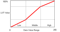
raster PLCS
piecewise linear contrast stretch for imagery
2015-03-25T13:06:55.564527+00:00
| Name | Author | Latest Version | Created On | Stars (votes) | ||||
|---|---|---|---|---|---|---|---|---|
|
|
QWater | 58,687 | Jorge Almerio | 2024-08-16T17:30:26.232718+00:00 | 2018-07-26T17:28:44.601369+00:00 |
(57)
|
3.3.2 | 3.0.1 |
|
|
QWaterModel | 15,563 | Florian Ellsäßer | 2023-02-15T14:42:19.328833+00:00 | 2020-01-29T14:08:29.807536+00:00 |
(13)
|
1.5 | 0.4 |
|
|
QWC2_Tools | 6,868 | Florent FOUGERES (Oslandia) | 2025-01-15T14:24:29.438175+00:00 | 2023-11-21T13:56:30.318943+00:00 |
(7)
|
v1.4.1 | 0.6.2 |
|
|
QWeb | 35,645 | Marios S. Kyriakou, George A. Christou, KIOS Research and Innovation Center of Excellence (KIOS CoE) | 2020-02-04T15:07:11.292060+00:00 | 2019-02-16T16:42:13.294100+00:00 |
(13)
|
0.2.1 | 0.1 |
|
|
Qweetgis | 2,048 | Alessandro Cristofori | 2019-01-22T19:22:40.211677+00:00 | 2019-01-22T19:22:40.002606+00:00 |
(6)
|
— | 0.1 |
|
|
RadialBandsTool | 4,832 | NecipEnesGENGEC | 2014-06-03T20:05:10.437742+00:00 | 2014-04-18T10:40:55.167202+00:00 |
(4)
|
— | 0.16 |
|
|
Radiation ToolBox Plugin | 1,780 | OpenGeoLabs s.r.o. | 2024-03-29T04:29:25.548388+00:00 | 2023-08-07T11:48:37.143212+00:00 |
(3)
|
— | 1.0.2 |
|
|
Radiotrack | 6,480 | Bello Fernando, Boisson Romain, Cabodi Alexis, Canon Louis-Claude, Jeannin Emile, Moyikoulou Chris-Féri, Wetzel Anthony | 2021-09-05T20:33:25.119467+00:00 | 2019-11-22T17:24:37.098169+00:00 |
(4)
|
0.12 | 0.1 |
|
|
RASOR Plugin | 5,210 | Joan Sala (Altamira-Information) | 2016-01-17T12:09:07.040909+00:00 | 2015-07-02T14:54:37.547141+00:00 |
(16)
|
3.0 | 2.2 |
|
|
raster2postgis | 3,878 | Geomaster | 2024-12-05T22:03:39.003273+00:00 | 2019-10-10T09:05:10.900716+00:00 |
(13)
|
1.0.4 | 1.0.1 |
|
|
RasterAttributeTable | 27,669 | Alessandro Pasotti | 2022-09-28T14:54:11.273813+00:00 | 2021-05-13T17:04:27.438382+00:00 |
(22)
|
1.2 | 1.0 |
|
|
Raster Bender | 12,926 | Olivier Dalang | 2016-05-29T21:43:52.559277+00:00 | 2014-11-17T15:18:49.003344+00:00 |
(15)
|
— | 0.0.7 |
|
|
Raster Data On Polylines | 2,903 | Sebastien Blaise | 2017-02-17T11:06:22.403411+00:00 | 2017-02-08T19:07:04.308009+00:00 |
(6)
|
— | 0.1.1 |
|
|
raster inversor | 2,028 | Sergio Carrera Fernández | 2019-03-07T22:01:26.049610+00:00 | 2019-03-07T22:01:25.179623+00:00 |
(0)
|
— | 0.1 |
|
|
RasterizeString | 5,106 | Mathieu Chailloux | 2019-04-03T12:57:41.232261+00:00 | 2019-04-03T12:57:40.122625+00:00 |
(4)
|
— | 0.1 |
|
|
Raster legend sensitive | 4,091 | Luiz Motta | 2016-02-19T11:07:29.571902+00:00 | 2016-02-18T01:01:14.993916+00:00 |
(6)
|
— | 0.3 |
|
|
RasterLoader | 3,833 | Lukas Krieger | 2016-03-04T08:27:19.350394+00:00 | 2016-03-03T16:51:09.041414+00:00 |
(3)
|
— | 1.1 |
|
|
RasterMCDA | 3,307 | Wallner Andreas Georg | 2023-05-15T05:47:28.471444+00:00 | 2021-02-26T10:10:46.568825+00:00 |
(7)
|
— | 1.3 |
|
|
Raster Pixel Count By ClassBreak | 6,592 | Kiwoong Kim (MangoSystem) | 2014-04-28T15:57:04.211462+00:00 | 2014-04-18T09:30:42.811582+00:00 |
(24)
|
— | 0.2.0 |
|
|
raster PLCS | 5,618 | gillian milani | 2015-03-25T13:06:55.564527+00:00 | 2015-03-24T17:36:43.319361+00:00 |
(11)
|
— | 0.12 |


